
OS Map ref: SH461681 53.188256,-4.302990

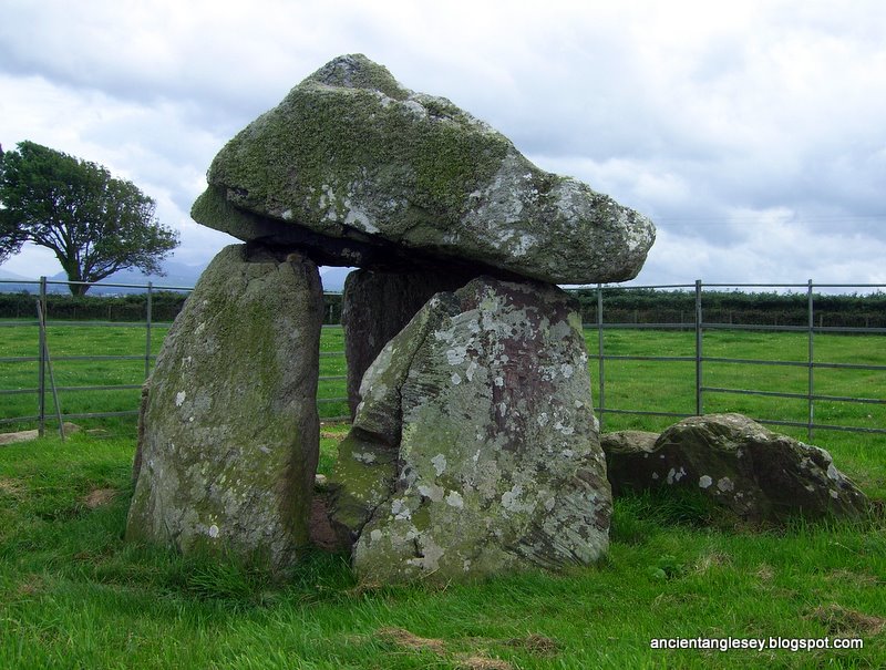
The site has never been excavated, but is assumed to have been a passage grave. The passage will have been to the eastern side where there is still a lower sill stone as seen in this photograph. According to Frances Lynch[1] the layout of Bodowyr may be compared with the other simple passage grave, Ty Mawr, also on the island and those at Carrowmore (Co. Sligo) and Burton (Pembrokeshire).
 To quote the Rev. J. Skinner in his extremely charming (if not always 100% accurate) writings of his trip around Anglesey in 1802[2], "That cromlechs were not always used (if they were at all) as altars for sacrifice I think may be demonstrated by the one before us (as its Pyramidical form is by no means adapted to the purpose. Indeed there is a tradition amongst the Welsh that this rude memorial was erected over the grave of a British princess named Bronwen who flourished in the year of the world 3105!!!!)"
The chamber consisted of four upright side stones (one is now fallen), topped by a huge mushroom shaped capstone. The sill stone at the entrance is not a common feature of simple passage graves like this one but does occur in more elaborate later ones like the Cruciform Passage Graves in Ireland[3].
Access
After crossing Stephenson's Britania bridge on the
 A55 turn first left onto the A5 towards Llanfairpwllgwyngyll. Just after passing the Marquess of Anglesey column turn left onto the A4080 Newborough road. Follow this road for 4.5 miles passing through Brynsiencyn and take the first right after a sharp left hand bend just before leaving the village, signposted for Caer Lêb Iron Age settlement. Pass by Caer Lêb down the hill and over the river up to a staggered crossroads. Go left and immediate right and the tomb is 500m on the right where there is space to park two cars. You will see the cromlech from the road, climb over stile to get into the field.
Gallery (click on thumbnails to view the larger picture and enter film strip viewer) or see my Bodowyr slideshow


| References / Further Reading |
|---|
| [1] Powell, Corcoran, Lynch, Scott. Megalithic Enquiries in the West of Britain 1969 (pp 117) |
| [2] Skinner, John. Ten Days Tour through The Isle of Anglesey 1802 (pp 15) |
| [3] Lynch, Frances. Prehistoric Anglesey 1970 (pp 28) |
| Bodowyr - Wikipedia, the free encyclopedia |
| GeoHack - Bodowyr - maps, photos, wiki and much more |
No comments:
Post a Comment